| Waltham Chase Mill - Geography
|

The geography of the Bishop’s Waltham Moors & Waltham Chase Mill can
be divided into the PHYSICAL and HUMAN
GEOGRAPHY |
PHYSICAL GEOGRAPHY
Location:
The Moors comprises an area of semi-natural woodland,
fen and grassland and open water situated in South Hampshire about 0.3km
south east of the small town of Bishop’s Waltham along the B2177 Winchester
to Fareham road, directly opposite Waltham Chase Mill.
Drainage and Topography:
|
|
Bishop’s Waltham is located in the Hampshire Basin, at
the spring line along the foot of the chalk downland. The low chalk hills
are close to the Moors rising up to the north of the site. The Moors itself
lies on poorly drained land at the head of a small tributary of the River
Hamble.
|
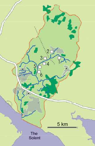
| There were once six watermills on
the Hamble – Waltham Chase Mill (1), Abbey Mill (2), Frog Mill (3), Durley
Mill (4), Maddoxsford Mill (5) and Botley Mill (6). These mills depended
on the reliable flows of water in this short fresh water length of the river. |
| All around The Moors are clays and
loam soils of the Hampshire Basin. The poorly drained soils of the Moors
are at the confluence of two small spring fed streams that flow towards
each other broadly parallel to the base of the chalk escarpment and converging
at the old millpond of Waltham Chase Mill. |
| These streams are themselves further fed by a
series of short spring fed streams within the Moors and this arrangement
of topography, geology and hydrology has given rise to a complex distribution
of poorly drained soils on which unusual plant communities have developed. |
Hydrological aspects:
|
The Environment Agency has kindly provided information on the rainfall,
ground water levels and water flow rates at the Moors. Further information
on the work of the Environment Agency can be found by visiting their web
site: www.environment-agency.gov.uk
|
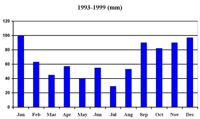 |
Rainfall – Average
annual rainfall in Bishop’s Waltham is around 800mm, in the winter rain
soaks into the chalk to recharge groundwater. As soon as vegetation starts
growing in the spring, recharge stops and groundwater levels start to
fall. The driest month is July with 29mm of rain on average.
|
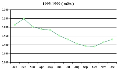 |
Flow rates – these
are recorded monthly by the Environment Agency immediately downstream of
the mill to record the supply of water from the many springs on the Moors.
The fastest period of flow tends to be in February with an average flow
of 0.25m³/s and the least flow is in late summer, with less than 0.1m³/s. |
|
Rivers on the chalk usually derive 90% of their flow from groundwater
with little annual variation. The pattern of flow is directly related
to groundwater levels.
|
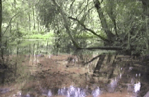
The water arising from the many springs on the Moors is calcareous coming
out of the chalk aquifer. Readings of pH have been recorded as high as 8.11.
Some of the slow flowing streams are so calcareous that calcium carbonate
forms as "tufa" on plant material and around twigs lying in the
water; these can sometimes form lumps 150mm long.
|
|
At the west end of the Moors is an area known as the
"Sandboils"; a very active spring head where water constantly
rises to the surface. Swirling sand particles in the numerous small springs
make the water appear as if it is boiling. The water is forced to the
surface by artesian pressure and can form small fountains breaking the
water surface after periods of prolonged heavy rainfall.
|
 |